
Progress!
|
|
|
|
|
|
|
|
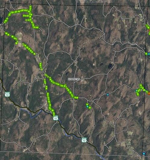
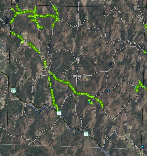
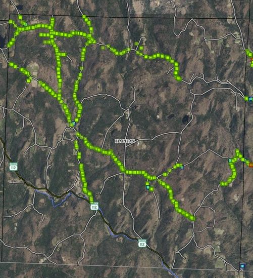
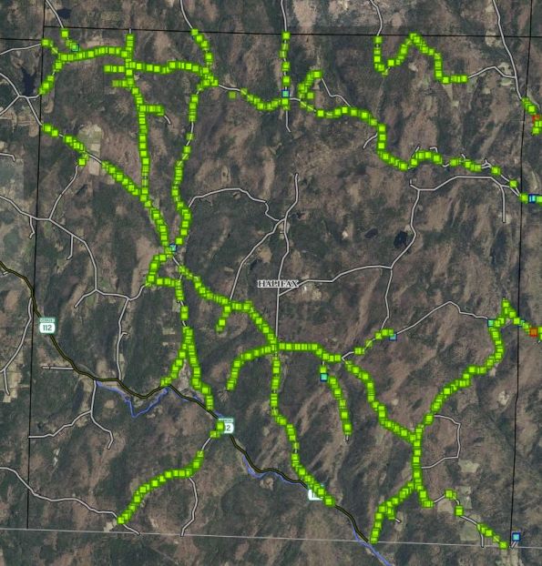
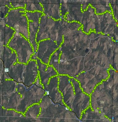
| Oct 30 2021 | Nov 7 2021 | Nov 11 2021 | Nov 18 2021 (...ANR hiatus...) | Oct 23 2022 | Oct 31 2022 | Nov 6 2022 |

|
| Halifax (west) and Guilford (east) in southeastern Vermont |
Resources:
Log into Vermont Ash Tree Inventory map. Same login as on your app (user: FPRPartner, pw: W0rktogether). Zoom in on Halifax on the southern border to see our progress. (Site has variable performance.)  QR code for site.
Halifax property boundaries 2017 Map of Halifax properties.
Vt Invasives org ash tree inventory process [helpful 7-minute video]
Vt Invasives org how-to on identifying ash trees -- they fail to mention the "stubby fingers" I consider a hallmark of ash trees in winter.
A video of how to use the app, Field Maps. The introduction is 1 min 45 sec long, so you might want to start at 1m45s if you just want to see how to log into and use the app.
MSU Ash Tree Identification handout - 2-sided color ID sheet on ash trees (Fraxinus).
What the EAB looks like, flecking / blonding by woodpeckers to get the larvae just under the bark, ladder-like tunnels of EAB larvae under the bark, thinning crown and other signs are illustrated in photos below.
Connecticut Tree Protective Association on EAB If you really want to see a lot more of that emerald ash borer egg, larva, pupa, and beetle...
OCT 2021 Halifax decisions on what to enter in Field Maps: Ash trees in ROW or UTILITY (optional PRIVATE). Min 4” diameter, categorized 4-12, 12-24, 24+. ROW extends 25' from centerline of road. For PRIORITY REMOVAL, choose NO (for a dead tree, you could choose UNKNOWN). Since we do not have any removal plan, trees are never "yes" on priority removal. Skip Route 112 as that is maintained by the State of Vermont.
Dr Kelly's notes on data entry
Get started:
BE SURE to coordinate with Dr Kelly BEFORE you inventory any road segments.
The goal of the ash tree inventory is a map of where the ash trees are along public roads, in the town Right Of Way (ROW).
To map where the ash trees are on Public roads, we use an app named Field Maps (aka ArcGIS Field Maps, ESRI Field Maps, and for older Androids, ArcGIS / ESRI Collector).
You need a GPS-enabled smart phone or iPad.
Download ArcGIS Field Maps app. If you cannot see this app, download ArcGIS Collector, the older version.
Load the app. Choose "ARCGis Online". Log in as user FPRPartner, with password W0rktogether — that first “o” is actually a zero.
In Field Maps, choose Roadside Ash Inventory to see the live map. You will appear as a glowing blue dot. Because generally you won't be on WiFi when inventorying trees, you will need to download a small piece of the live map for use offline.
Go back to where you see Roadside Ash Inventory and the ellipsis (...) by it. Choose the ellipsis (...). Now choose “add offline area” to download a map. The “Level of detail:” defaults to “Room”. This lets you see the most detail. If you change to “Small building” (by tapping the word room) the download will go more quickly but be blurrier. Close in on a small area in Halifax of 1/2 to 2 miles max dimension. I chose half of my road, Hanson Road, as it’s <2 miles long. Choose the area you want to inventory. Download it. Rename it from "Area 1" (or other number) to wherever it is, e.g., "Halifax Center-Jville Stage" or "Deer Park to GRR".
Downloading a small area map lets you enter data points (trees) without being connected to the internet (walking along the road).
At this point you’re ready to go out and add trees to your map. Walk along the left side of the road until you see an ash tree within the ROW on the left side. (Do only 1 side of the road at a time.) When you are opposite the ash tree, hit + to add the data point, then choose "no" for Priority Removal, then touch "ADD POINT", then touch the dialog box by Date so that auto-fills, then scroll down to COUNT and if multiple trees change COUNT from 1 to however many trees are right there (all same size). Next, if tree is 4-12 inches across, leave DIAMETER CLASS at 0-12" but if tree is >1 foot choose 12-24" or if tree is >2 feet choose 24"+. Next choose condition "GOOD" unless the tree is "DEAD", leave "ROW" unless the tree is within 10 feet of UTILITY line, tap TOWN and type "HAL" and choose HALIFAX. (For the rest of the session, Halifax will be presented first.) Then hit SUBMIT or the check mark in the top right corner. Continue to the next tree. After a while, perhaps 0.4 miles, stop at a memorable location, such as someone's mailbox. Cross the road and retrace your path back to your car, adding the ash trees on the other side of the road.
When you come back inside where there’s WiFi, immediately SYNC to upload your work to the state website. Then you can either go out another day to add more trees to it, or delete your offline map and get another one. Always synchronize (upload your data points) immediately after a session on the road.
You cannot see the live map on your device as long as you have an offline map on your device, but you can add more offline maps from that ellipsis.
About Emerald Ash Borer (EAB)
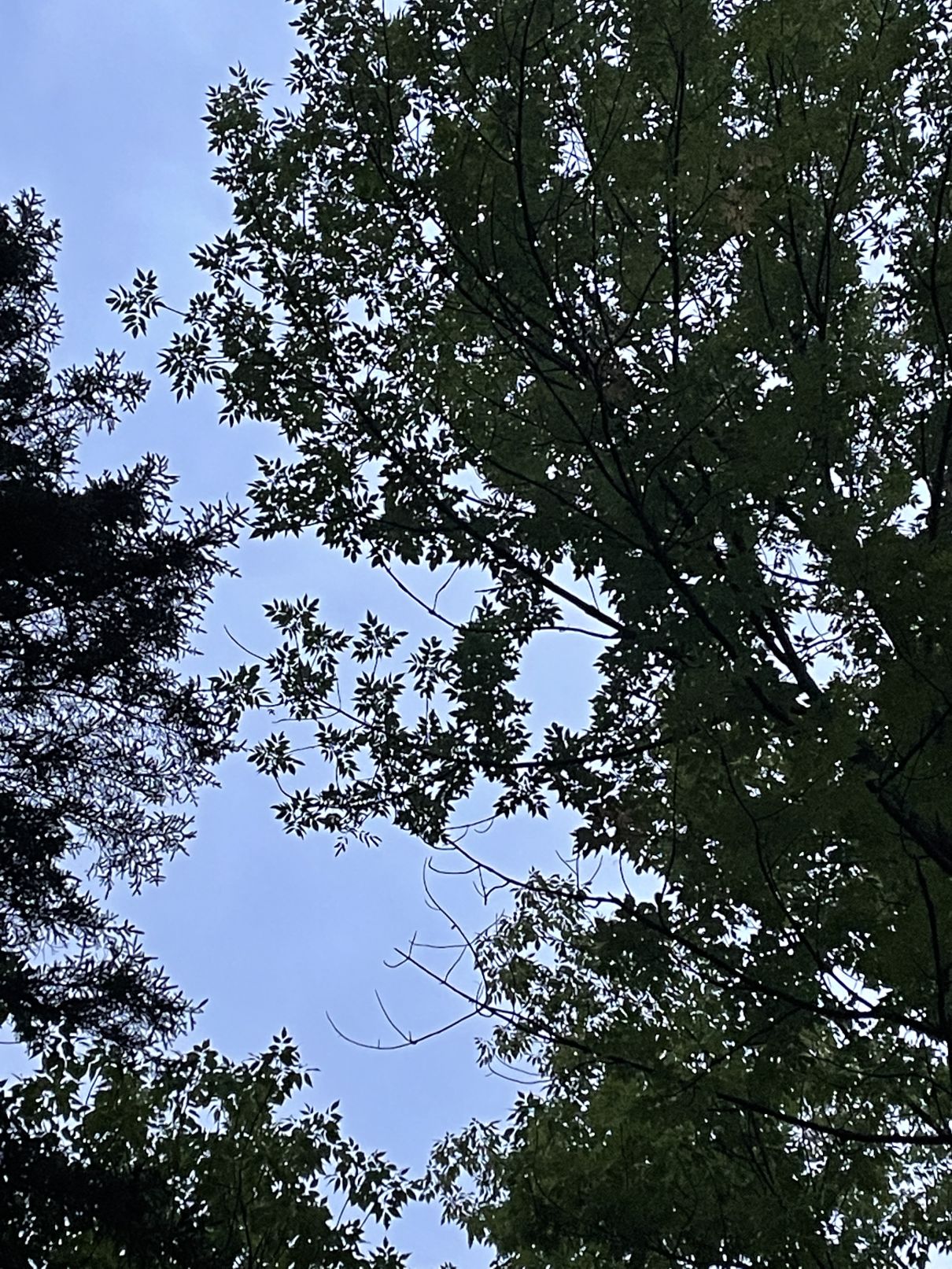
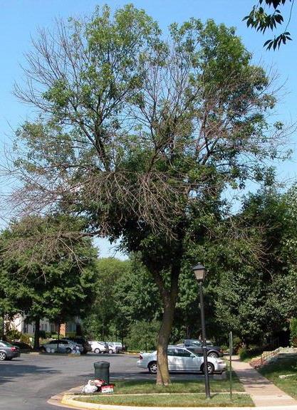
| Ash tree canopy showing compound leaves and stubby fingers of opposing branches: | Thinning canopy caused by EAB |
 canopy canopy
|
 canopy canopy
|
| Ash tree saplings on Hanson Road: | Epicormic shoots near base of an EAB-infested ash tree: |
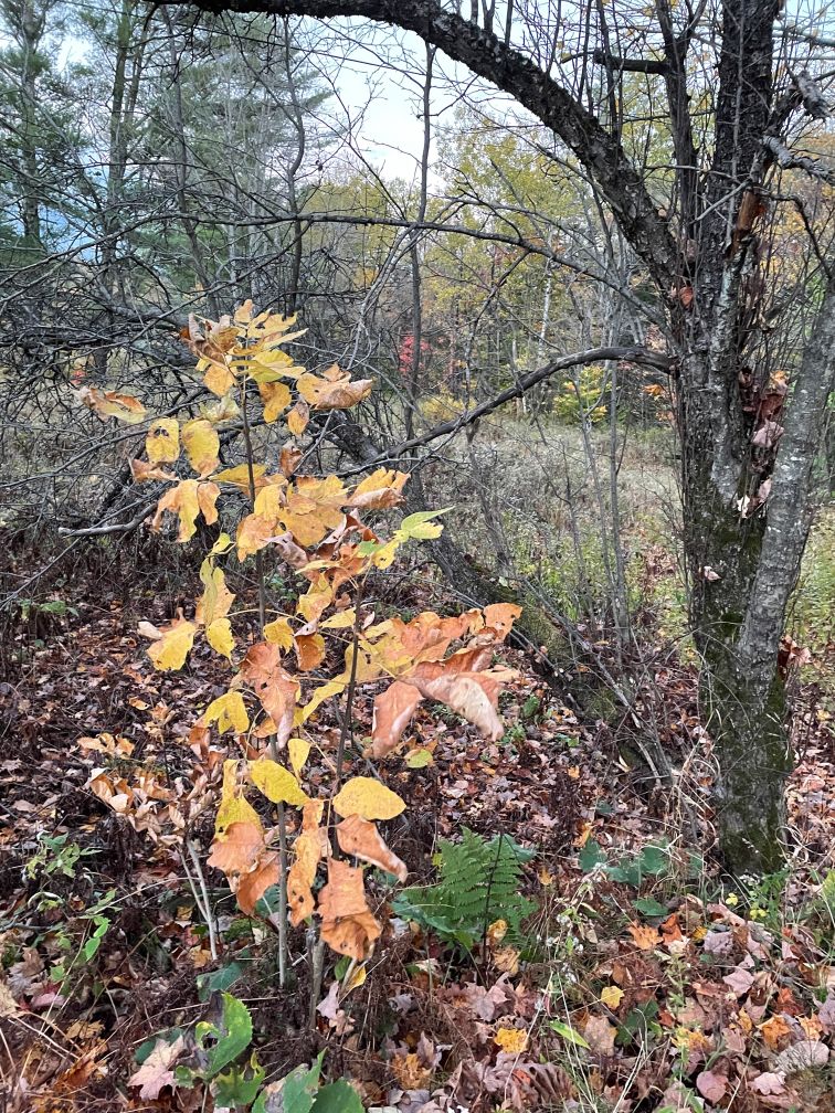 saplings saplings
|
 epicormic shoots epicormic shoots
|
| Ash tree trunk on Hanson Road: | Flecking or blonding -- evidence of woodpeckers pecking off the bark to eat EAB larvae: |
 trunk trunk
|
 bark bark
|
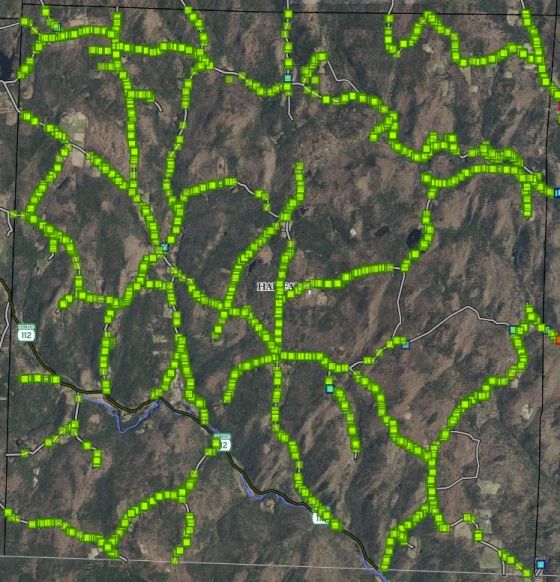
| Goal: Field Maps image of Guilford (completed 2020) | |
 map map
|